Colophon and ground rules
About this notebook
What Field Hours is, how its drawings are made, and what it deliberately does not claim.
Field Hours is a personal notebook about the smallest useful unit of hill walking: the half-day near town. It collects working notes under three headings — planning a half-day, reading terrain and routes, and looking after kit — and tries to keep each note short enough to finish and exact enough to check.
The sample hill
Every map on this site is a view of one drawing, Sheet 00. It shows a hill with two tops and a saddle between them, two spurs running south, a re-entrant with a stream, a brook and a lane in the valley, and a block of plantation on the south-west slope. A loop of 9.8 km with 385 m of climb runs over both tops and back along the lane.
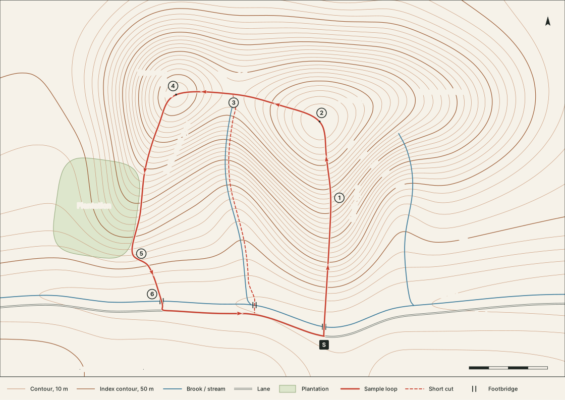
The hill is not a disguised real one. Its shape is a handful of smooth mathematical bumps added together; the contours are traced from that surface, the streams follow its lowest lines, and the loop’s distances and heights are measured along it. Feature names are deliberately plain — Main top, the brook, Plantation — so that nothing reads as a place you could look up.
What the notes do not claim
- No real places. No note describes, rates or recommends an actual hill, path or car park.
- No trip reports. Nothing here records an outing. Worked examples are worked on paper.
- No safety guarantees. A time budget or a check point is a planning aid. Weather, ground, daylight and the people in the party decide what is sensible on the day, and a current map and forecast outrank anything written here.
- No endorsements. Kit notes describe materials and methods, not makes or models. Where care is concerned, the label and the maker’s instructions come first.
How the figures are made
| Figure | Source | Shown as |
|---|---|---|
| Contour maps | Traced from the invented height field at a 10 m interval | SVG line drawings |
| Loop distances, climbs, heights | Measured along the route on the same surface | Tables and the profile chart |
| Time estimates | Naismith’s rule applied to those measurements | Tables and charts |
| Slope angles | Plain trigonometry | Table and diagram |
| Boot and fabric diagrams | Drawn as schematics | SVG, labelled schematic |
Each figure carries an Illustrative tag so that a drawing lifted out of context still says what it is.
Colophon
The pages are static files built with Hugo. Text is set in typefaces already on the reader’s machine — a Palatino-style serif for reading, a plain sans for labels and tables — so nothing is fetched from elsewhere. There are no analytics, cookies, comment forms or embedded media. The design is tuned for a desktop browser.