Half-Days
Fitting a proper walk into four hours: budgeting the time, estimating the pace and choosing a route shape that can shrink.
A personal notebook · 11 notes · one invented hill
Field Hours is a notebook for the half-day walk near town: how to fit one into four hours, how to read the shape of a hill before standing on it, and how to keep boots and a rain shell working between outings.
From the front page down to a single fold in a hillside.
Fitting a proper walk into four hours: budgeting the time, estimating the pace and choosing a route shape that can shrink.
Reading the shape of the ground from contour lines, and using what the map shows to hold a route together.
Keeping boots, a rain shell and a small pack working: what to clean, how to dry it, and when to leave it alone.
The sample loop in numbers
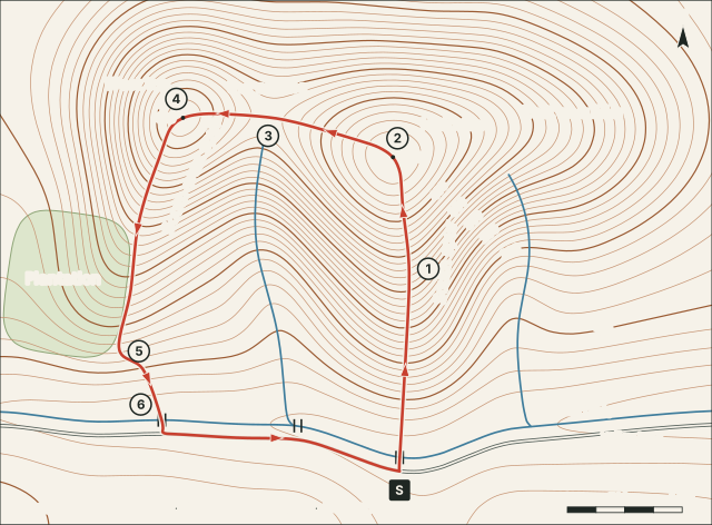
Rather than a new anecdote in every note, the notebook keeps one invented loop and measures it properly. The figures below come from the same height field as the drawing above, so the map, the profile and the tables always agree.
| Leg | From | To | km | Climb, m | Drop, m | Estimate | Running total | Height at end, m |
|---|---|---|---|---|---|---|---|---|
| S–1 | Lay-by on the lane | Spur shoulder | 1.8 | 215 | 0 | 43 min | T+0:43 | 330 |
| 1–2 | Spur shoulder | Main top | 1.0 | 120 | 0 | 24 min | T+1:07 | 450 |
| 2–3 | Main top | Saddle | 1.2 | 0 | 85 | 14 min | T+1:21 | 366 |
| 3–4 | Saddle | West top | 0.7 | 50 | 0 | 13 min | T+1:34 | 416 |
| 4–5 | West top | Plantation corner | 2.1 | 0 | 240 | 25 min | T+1:59 | 174 |
| 5–6 | Plantation corner | West footbridge | 0.8 | 0 | 50 | 10 min | T+2:09 | 124 |
| 6–S | West footbridge | Lay-by on the lane | 2.2 | 0 | 10 | 26 min | T+2:35 | 117 |
| Whole loop | 9.8 | 385 | 385 | 2 h 35 | ||||
Illustrative. 12 min per km + 10 min per 100 m of ascent; legs rounded to the minute.
Note 01 · Planning
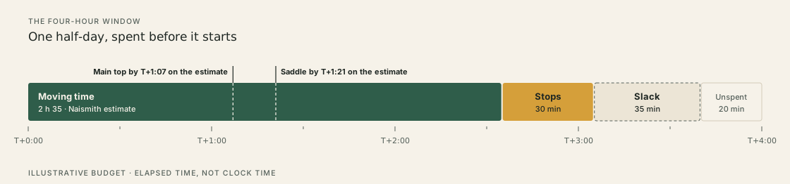
A half-day is a fixed container. Fill it on paper first: moving time, stops, slack, and a little left deliberately unspent.
Note 02 · Planning
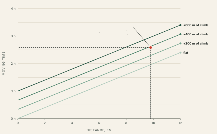
Twelve minutes a kilometre, ten minutes for every hundred metres of climb. The oldest rule of thumb in hill walking, and what it leaves out.
Note 03 · Route Shapes
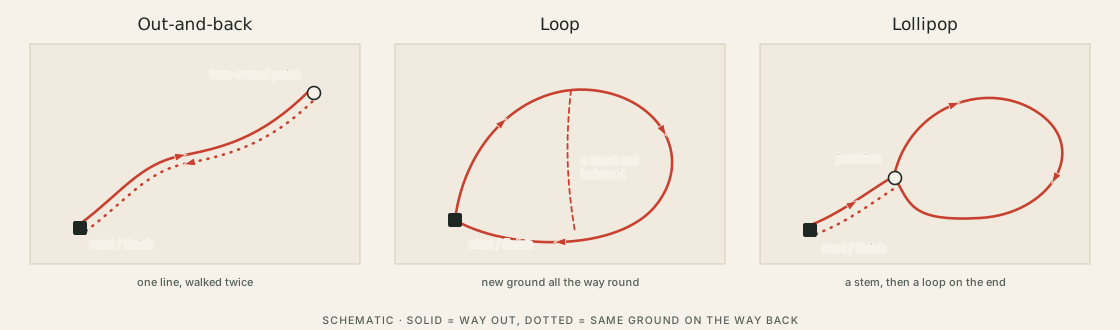
Three shapes for a short walk, compared by how much new ground they give and how easily they can be cut short.
Three places on the sample loop where the watch is compared with the plan, and the one line that turns a late loop into a shorter one.
The same bend in a contour line can be a ridge or a valley. Which one it is depends on a single question: where is downhill?
How far apart the lines sit is a measurement, not an impression. A small lookup table turns millimetres on the map into degrees on the ground.
Four ordinary navigation ideas, worked through on one descent: something to follow, something to stop at, somewhere to start being careful.
A route seen side-on shows where the effort falls. It also exaggerates, and leaves out nearly everything else.
A five-step routine for boots: knock, strip, wash, dry slowly, and treat only when the material asks for it.
A shell that feels wet inside is not always leaking. Often the outer fabric has soaked, and the fix is a wash, a little heat and sometimes a re-proof.
Fifteen minutes after every walk does more for kit than an occasional big clean. A rhythm of four intervals, and what belongs in each.
Each note takes one small idea and works it through on the same invented hill, Sheet 00. Where a note needs numbers, they are measured from that drawing rather than remembered from a day out, so they can be checked line by line.
That also means the notes make no claims about real places. There are no trip reports here, no route recommendations and no promises about what is safe. The aim is narrower: methods that can be practised on paper and then carried to whatever map and ground are actually in front of you.