Note 05 · Terrain / Contours
Spurs and re-entrants
The same bend in a contour line can be a ridge or a valley. Which one it is depends on a single question: where is downhill?
Follow one contour line across a hillside and it wanders: out around a bulge, back into a fold, out again. Every bulge is a spur, a rib of higher ground running down from the hill. Every fold is a re-entrant, a small valley cut back into it.
On paper the two look alike. Each is a bend, a U or a V, in a stack of roughly parallel lines. What separates them is direction.
Working rule
If the bends point toward lower ground, it is a spur. If they point toward higher ground, it is a re-entrant.
Four shapes worth knowing by sight
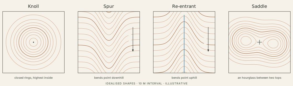
A knoll is a set of closed rings with the highest ground inside. A saddle is what lies between two of them: the lowest point on the ridge joining two tops, and at the same time the highest point of the pass between two valleys. On the map the contours pinch into an hourglass.
Finding downhill
The rule needs a direction, and the lines alone do not give one. Three things on most maps do:
- Water. Streams run in re-entrants and flow downhill. A blue line sitting in a row of bends settles the question at once.
- Numbers. Index contours carry heights, and spot heights mark tops. Two labelled lines give the direction of the whole slope between them.
- Closed rings. Unless the map marks it as a hollow, a small closed contour is a top, and everything slopes away from it.
The south side of the sample hill
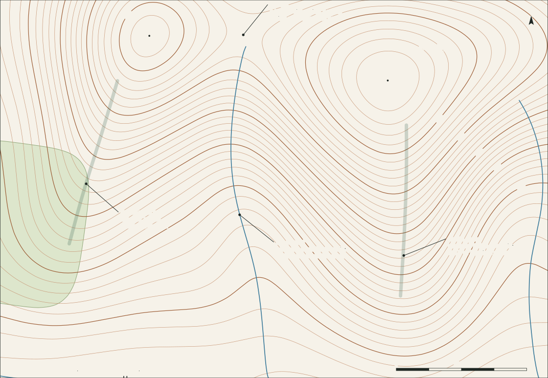
All four shapes appear in this one view.
| Shape | Where on the sheet | How the contours show it | What it does to a route |
|---|---|---|---|
| Spur | South spur, from the lane to the main top | Bends bulge south, toward the brook | The first two legs of the loop follow its crest |
| Spur | South-west spur, below the west top | The same, but broader and rounder | The descent to the plantation corner follows it |
| Re-entrant | Between the two spurs | Bends cut back north, toward the saddle; a stream in the crease | Holds the dashed short cut |
| Saddle | Between the tops, at 366 m | Hourglass: the 400 m line closes separately round each top | The low point of the high ground, and the head of the re-entrant |
Two details repay a second look. The south spur is narrow, so its bends are tight; the south-west spur is broad, so the same feature reads as a gentle swelling that is easy to miss. And the stream does not start at the saddle itself but a little below it, where the fold becomes sharp enough to gather water.
Why the difference matters on a short walk
A spur and a re-entrant offer opposite kinds of line. On a spur crest the ground falls away on both sides, so drifting off it is noticeable underfoot; on a broad spur that cue is much weaker. A re-entrant gathers things: water, and often the easiest line for anything flowing or walking downhill, which is why paths and streams so often share one.
Neither is better. The useful habit is to name the shape before stepping onto it — spur, then saddle, then spur is the whole high part of the sample loop — and to notice when the ground stops matching the name.