Note 07 · Terrain / Route Reading
Handrails, catching features, attack points
Four ordinary navigation ideas, worked through on one descent: something to follow, something to stop at, somewhere to start being careful.
Finding a small thing in a large landscape is hard. Finding a long thing is easy. Most practical navigation is the art of swapping the first problem for the second: reaching a line that cannot be missed, then following it to the point that could.
This note uses the last descent of the sample loop, from the west top to the west footbridge, to put four standard terms to work.
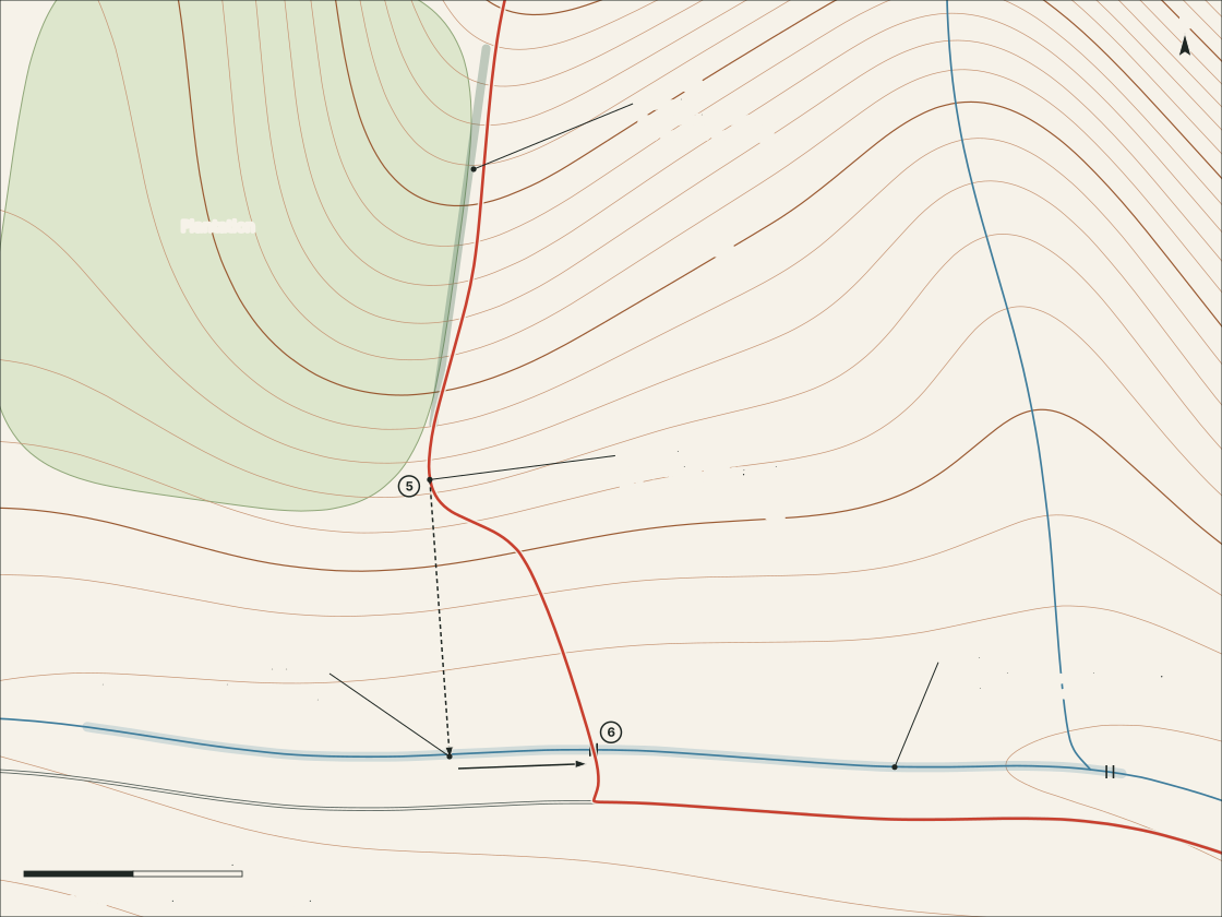
The four ideas
| Term | What it is | On the sample descent | How it lets you down |
|---|---|---|---|
| Handrail | A line feature that runs roughly the way you want to go: a path, stream, wall, forest edge or ridge crest | The east edge of the plantation, followed down the spur | It bends away from your direction and you follow it anyway |
| Catching feature | A line feature lying across your direction of travel, beyond the target. Reaching it means you have gone far enough | The brook, with the lane just behind it | It is fainter on the ground than on the map, or there are two alike |
| Attack point | An unmistakable feature close to the target, from which the last short leg is done with care | The plantation corner, waypoint 5 | It is chosen too far away, so the careful part is too long |
| Aiming off | Deliberately heading to one known side of a target that sits on a line feature | Aiming upstream of the footbridge, then turning downstream | You forget which side you aimed for |
Putting them in order
The descent divides into a coarse part and a fine part.
Coarse: west top to plantation corner. This is leg 4–5: 2.1 km and 240 m of descent down the south-west spur. The spur is broad, so its crest alone is a weak guide. About half-way down, the plantation’s edge comes in from the west and runs south beside the line of travel. From there the instruction is simply keep the trees on the right.
Fine: plantation corner to footbridge. At the corner the trees turn away west and the handrail ends. That is exactly what makes it a good attack point: a place that is hard to mistake, less than a kilometre short of the target. From here the footbridge is a small object on a long brook.
Aiming off
Walking straight at the bridge from the corner sounds efficient. But any small error leaves you standing on the bank with no bridge in sight and no way to know whether it is to the left or the right.
The dashed line on the figure shows the alternative: aim clearly upstream of the bridge. The brook is the catching feature, so it will be reached regardless. When it is, there is no doubt which way to turn: downstream, with the water as a handrail, until the bridge appears.
Working rule
When the target sits on a line, do not aim at the target. Aim at the line, to one chosen side, and let the line take you in.
The cost is a little extra distance: about 240 m here, measured against the straight line from corner to bridge. What it buys is the removal of a guess.
Three cautions
Features on a map are a record of the day it was surveyed. Plantations are felled and replanted, fences move, paths shift. Contours change least, which is one reason to learn the shapes first and treat everything printed on top of them as provisional.
A handrail is only as good as the check that ends it. Before following one, decide what will mark the point to leave it: here, the corner.
And these techniques narrow errors; they do not remove them. They are habits for staying found, not a guarantee of it.